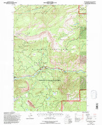
1992 Map of Tieton Basin
USGS Topo · Published 1996About this map
Tieton River drainage dominates this 1990s terrain, where the Tieton Basin meets the Mt Baker Snoqualmie National Forest. The landscape is a network of ridges and high points, including Bethel Ridge to the north and Divide Ridge to the south, framing the valley floor. Human activity is clustered around the river and the eastern edge of Rimrock Lake, with the settlement of Rimrock and the Tieton Work Center serving as primary hubs.
Find a feature on this map
41 named features on this map. Tap any name to fly to it.
Don’t see what you’re looking for? This feature index may not catch every label — zoom into the map to look around manually.
Map Details
Editions of this 1992 Tieton Basin Map
This is the sole edition of this map. No revisions or reprints were ever made.
Other maps of this area

1899 · Ellensburg
USGS Topo · 1:125,000

1901 · Ellensburg
USGS Topo · 1:125,000

1902 · Mount Aix
USGS Topo · 1:125,000

1904 · Mt Aix
USGS Topo · 1:125,000

1950 · Yakima
USGS Topo · 1:250,000

1958 · Yakima
USGS Topo · 1:250,000

1961 · Yakima
USGS Topo · 1:250,000

1967 · Rimrock Lake
USGS Topo · 1:24,000

1967 · Tieton Basin
USGS Topo · 1:24,000

1967 · Darland Mtn
USGS Topo · 1:24,000