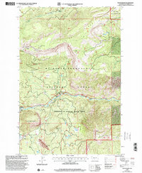
2000 Map of Tieton Basin
USGS Topo · Published 2001About this map
Tieton River carves through this mountain landscape at the turn of the 21st century, serving as the central artery for a series of recreational sites including Hause Creek Campground, River Bend Campground, and Wild Rose Campground. The area is a complex of managed lands, where the Tieton Basin meets the Mt Baker Snoqualmie National Forest. Notable landmarks such as the distinctive Kloochman Rock and the high peaks of Goose Egg Mountain frame the valley.
Find a feature on this map
43 named features on this map. Tap any name to fly to it.
Don’t see what you’re looking for? This feature index may not catch every label — zoom into the map to look around manually.
Map Details
Editions of this 2000 Tieton Basin Map
This is the sole edition of this map. No revisions or reprints were ever made.
Other maps of this area

1899 · Ellensburg
USGS Topo · 1:125,000

1901 · Ellensburg
USGS Topo · 1:125,000

1902 · Mount Aix
USGS Topo · 1:125,000

1904 · Mt Aix
USGS Topo · 1:125,000

1950 · Yakima
USGS Topo · 1:250,000

1958 · Yakima
USGS Topo · 1:250,000

1961 · Yakima
USGS Topo · 1:250,000

1967 · Rimrock Lake
USGS Topo · 1:24,000

1967 · Tieton Basin
USGS Topo · 1:24,000

1967 · Darland Mtn
USGS Topo · 1:24,000