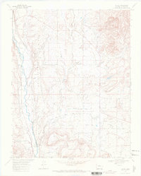
1968 Map of Tiffany
USGS Topo · Published 1972About this map
Shellhammer Ridge and Indian Mesa dominate this Southern Colorado landscape, where the high-desert terrain meets an intricate system of managed water. Irrigation infrastructure is central to the area's development, evidenced by the Pine River Canal and numerous ditches like the Commissioner Ditch and Ute Ditch that lace the territory. The settlement of Tiffany serves as a local hub, situated near the Old Railroad Grade which suggests a shifting transportation network during the mid-20th century.
Find a feature on this map
30 named features on this map. Tap any name to fly to it.
Don’t see what you’re looking for? This feature index may not catch every label — zoom into the map to look around manually.
Map Details
Editions of this 1968 Tiffany Map
This is the sole edition of this map. No revisions or reprints were ever made.
Other maps of this area

1889 · Largo
USGS Topo · 1:250,000

1895 · Largo
USGS Topo · 1:250,000

1908 · Ignacio
USGS Topo · 1:125,000

1924 · Ignacio
USGS Topo · 1:125,000

1924 · Pagosa Springs
USGS Topo · 1:125,000

1927 · Pagosa Springs
USGS Topo · 1:125,000

1945 · Durango
USGS Topo · 1:250,000

1953 · Durango
USGS Topo · 1:250,000

1954 · Durango
USGS Topo · 1:250,000

1954 · Allison
USGS Topo · 1:24,000