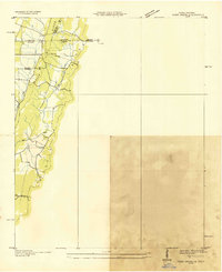
1935 Map of Tiger Creek
USGS Topo · Published 1935About this map
The Tennessee and Georgia state line divides this 1935 advance sheet, where the Southern railroad cuts through the terrain at White Cut. This survey, compiled from aerial photographs by the Tennessee Valley Authority and USGS, documents a landscape shaped by the prominent elevations of White Oak Ridge and Chutta Ridge. The map captures a moment of infrastructure development in the mid-1930s, showing the early path of the Ga Pwr Line alongside the natural drainage of Tiger Creek and Cat Creek. Located at the intersection of Hamilton and Bradley counties in Tennessee and Catoosa and Whitfield counties in Georgia, the sheet highlights the complex administrative boundaries of the tri-state area. The inclusion of trails and ridge lines provides a detailed look at the rural connectivity and land use before the expansion of modern highway systems.
Find a feature on this map
12 named features on this map. Tap any name to fly to it.
Don’t see what you’re looking for? This feature index may not catch every label — zoom into the map to look around manually.
Map Details
Editions of this 1935 Tiger Creek Map
This is the sole edition of this map. No revisions or reprints were ever made.
Other maps of this area

1886 · Dalton
USGS Topo · 1:125,000

1886 · Cleveland
USGS Topo · 1:125,000

1886 · Ringgold
USGS Topo · 1:125,000

1888 · Chattanooga
USGS Topo · 1:125,000

1892 · Ringgold
USGS Topo · 1:125,000

1892 · Cleveland
USGS Topo · 1:125,000

1892 · Dalton
USGS Topo · 1:125,000

1893 · Chattanooga
USGS Topo · 1:125,000

1895 · Cleveland
USGS Topo · 1:125,000

1897 · Dalton
USGS Topo · 1:125,000