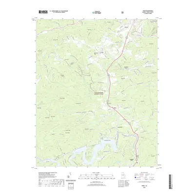
2020 Map of Tiger
USGS Topo · Published 2020About this map
The Tallulah River corridor defines this portion of the Blue Ridge, where the mountain settlements of Tiger, Wiley, and Lakemont follow the valley floor. High-altitude peaks like Screamer Mtn and Tiger Mtn loom over the terrain, much of which is protected within the Chattahoochee National Forest. This modern survey illustrates a landscape deeply shaped by recreation and water management, featuring Lake Rabun to the south and the Athens YMCA Camp Lake. Genealogists will find several family-named burial sites, including Roane Cem, Cruckleton Cem, and Jameson Cem, often located near ridges and old wagon routes. Infrastructure like the Wiley Trestle and the Paul A Green Bridge highlight the engineering required to traverse this mountain geography, while the Big Creek Flying Ranch Airport and the Stonewall Falls Mountain Bike Trail reflect the area's contemporary role as a destination for outdoor enthusiasts.
Find a feature on this map
126 named features on this map. Tap any name to fly to it.
Don’t see what you’re looking for? This feature index may not catch every label — zoom into the map to look around manually.
Map Details
Editions of this 2020 Tiger Map
This is the sole edition of this map. No revisions or reprints were ever made.
Other maps of this area

1886 · Dahlonega
USGS Topo · 1:125,000

1886 · Walhalla
USGS Topo · 1:125,000

1892 · Dahlonega
USGS Topo · 1:125,000

1892 · Walhalla
USGS Topo · 1:125,000

1896 · Walhalla
USGS Topo · 1:125,000

1896 · Dahlonega
USGS Topo · 1:125,000

1903 · Dahlonega
USGS Topo · 1:125,000

1935 · Dillard
USGS Topo · 1:24,000

1935 · Rabun Bald
USGS Topo · 1:24,000

1935 · Hightower Bald
USGS Topo · 1:24,000