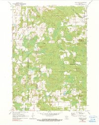
1970 Map of Tigerton NW
USGS Topo · Published 1990About this map
The Little Wolf River and the South Branch Embarrass River define the hydrography of this Wisconsin landscape, where four counties—Marathon, Shawano, Portage, and Waupaca—meet. The terrain is a complex mix of wooded lowlands and small agricultural clearings, dotted with gravel pits and drained by a dense network of streams including Comet Creek, Steinke Creek, and Bradley Creek. Small rural settlements like Norske and Wolf serve as local hubs for a road system that often follows township lines, such as Township Road and Franzen Road.
Find a feature on this map
34 named features on this map. Tap any name to fly to it.
Don’t see what you’re looking for? This feature index may not catch every label — zoom into the map to look around manually.
Map Details
Editions of this 1970 Tigerton NW Map
2 editions found
Other maps of this area

1899 · Wausau
USGS Topo · 1:125,000

1902 · Wausau
USGS Topo · 1:125,000

1953 · Hatley
USGS Topo · 1:48,000

1954 · Wittenberg
USGS Topo · 1:48,000

1955 · Tigerton
USGS Topo · 1:48,000

1955 · Rosholt
USGS Topo · 1:48,000

1955 · Green Bay
USGS Topo · 1:250,000

1964 · Wittenberg
USGS Topo · 1:62,500

1964 · Hatley
USGS Topo · 1:62,500

1969 · Rosholt
USGS Topo · 1:24,000