
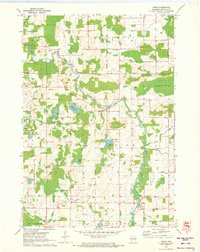
1970 Map of Clintonville North
USGS Topo · Published 1973About this map
Pella Swamp dominates the central landscape of this 1970 survey, forming a natural division between the northern and southern agricultural reaches of Shawano and Waupaca Counties. To the north, the village of Pella sits at the junction of Pella Pond and the Embarrass River, a landscape marked by numerous Gravel Pits and rural religious sites like the Bethlehem Ch Cem. The southern half of the map transition into the township of Larrabee, where the Chicago and North Western railroad corridor shapes the growth of Marion and Clintonville.
Find a feature on this map
50 named features on this map. Tap any name to fly to it.
Don’t see what you’re looking for? This feature index may not catch every label — zoom into the map to look around manually.
Map Details
Editions of this 1970 Clintonville North Map
This is the sole edition of this map. No revisions or reprints were ever made.
Other maps of this area

1954 · Gresham
USGS Topo · 1:48,000

1954 · Shawano
USGS Topo · 1:48,000

1955 · Embarrass
USGS Topo · 1:48,000

1955 · Clintonville
USGS Topo · 1:48,000

1955 · Green Bay
USGS Topo · 1:250,000

1964 · Shawano
USGS Topo · 1:62,500

1964 · Gresham
USGS Topo · 1:62,500

1969 · Embarrass
USGS Topo · 1:24,000

1969 · Bear Creek
USGS Topo · 1:24,000
1970 · Symco
USGS Topo · 1:24,000