
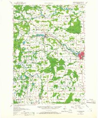
1955 Map of Clintonville
USGS Topo · Published 1957About this map
The Embarrass River and its multiple branches define the drainage of this central Wisconsin landscape, where mid-century dairy farming and small-town industry intersect. The Chicago and North Western railroad corridor serves as the primary spine for development, linking Marion and Clintonville, where the rails run alongside Pigeon Lake. This era shows a rural landscape in transition, documented by numerous country schools like Sunrise Sch and Morning Star Sch, alongside several that were already labeled as abandoned, such as McKinley Sch and Elm Dale Sch. Genealogists will find a high density of rural burial sites, including Graceland Cem, Zion Cem, and the Danish Cem near Beaver Creek. The map also captures several distinct townships, including Larrabee and Grant, during a period of established agricultural stability before modern highway expansions altered the local road network.
Find a feature on this map
86 named features on this map. Tap any name to fly to it.
Don’t see what you’re looking for? This feature index may not catch every label — zoom into the map to look around manually.
Map Details
Editions of this 1955 Clintonville Map
2 editions found
Other maps of this area

1954 · Wittenberg
USGS Topo · 1:48,000

1954 · Gresham
USGS Topo · 1:48,000

1954 · Shawano
USGS Topo · 1:48,000

1955 · Embarrass
USGS Topo · 1:48,000

1955 · Tigerton
USGS Topo · 1:48,000

1955 · Green Bay
USGS Topo · 1:250,000

1956 · New London
USGS Topo · 1:48,000

1956 · Weyauwega
USGS Topo · 1:48,000

1957 · Waupaca
USGS Topo · 1:48,000

1964 · Wittenberg
USGS Topo · 1:62,500