
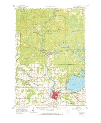
1964 Map of Shawano
USGS Topo · Published 1965About this map
The Wolf River and its turbulent West Branch dominate this mid-century landscape, carving through the Menominee Indian Reservation. The river's path is marked by a sequence of dramatic drops, including Big Eddy Falls, Keshena Falls, and Wayka Falls. In the south, the city of Shawano serves as a regional hub at the outlet of Shawano Lake, supported by the Chicago and North Western railroad and the Shawano Municipal Airport. The map documents a diverse institutional presence, from the Alexian Brothers Novitiate near Red River to the Keshena School and the Spirit Rock Historic Marker. Local heritage is preserved in numerous community sites like the West Branch Cemetery and Rest Haven Cemetery, while the northern forests are monitored from the Kinepoway Lookout Tower.
Find a feature on this map
89 named features on this map. Tap any name to fly to it.
Don’t see what you’re looking for? This feature index may not catch every label — zoom into the map to look around manually.
Map Details
Editions of this 1964 Shawano Map
2 editions found
Other maps of this area

1942 · Breed
USGS Topo · 1:48,000

1952 · White Lake
USGS Topo · 1:48,000

1952 · Langlade
USGS Topo · 1:48,000

1952 · Mountain
USGS Topo · 1:48,000

1954 · Gresham
USGS Topo · 1:48,000

1954 · Shawano
USGS Topo · 1:48,000

1954 · Iron Mountain
USGS Topo · 1:250,000

1955 · Embarrass
USGS Topo · 1:48,000

1955 · Clintonville
USGS Topo · 1:48,000

1955 · Seymour
USGS Topo · 1:62,500