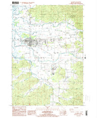
1985 Map of Tillamook
USGS Topo · Published 1985About this map
Tillamook serves as the hub of this mid-1980s landscape, where a complex network of waterways meets the northeastern edge of Tillamook Bay. The town is defined by its proximity to four major rivers: the Kilchis River, Wilson River, Trask River, and Tillamook River. These channels, alongside intricate drainage features like Squeedunk Slough and Wooden Pole Slough, dominate the low-lying valley floor. The geography is characterized by the transition from these tidal flats and river bottoms to the rising timberlands of the Tillamook State Forest.
Find a feature on this map
45 named features on this map. Tap any name to fly to it.
Don’t see what you’re looking for? This feature index may not catch every label — zoom into the map to look around manually.
Map Details
Editions of this 1985 Tillamook Map
This is the sole edition of this map. No revisions or reprints were ever made.
Other maps of this area

1937 · Nehalem
USGS Topo · 1:62,500

1937 · Enright
USGS Topo · 1:62,500

1941 · Enright
USGS Topo · 1:62,500

1942 · Ginger Peak
USGS Topo · 1:62,500

1942 · Tillamook
USGS Topo · 1:62,500

1943 · Nehalem
USGS Topo · 1:62,500

1948 · Vancouver
USGS Topo · 1:250,000

1950 · Vancouver
USGS Topo · 1:250,000

1950 · Vancouver
USGS Topo · 1:250,000

1955 · Blaine
USGS Topo · 1:62,500