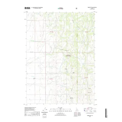
2020 Map of Timber Butte
USGS Topo · Published 2020About this map
Timber Butte stands as a central topographic landmark in this high-elevation landscape along the Twin Falls and Cassia county line. The terrain is defined by a dense network of drainages and springs within the Sawtooth National Forest, illustrating a complex hydrological system where seasonal flows like Cottonwood Creek and Goose Creek emerge from family-named water sources. Insights into early land use are visible through features such as Basque Spring and Indian Camp Spring, which suggest a history of seasonal grazing and movement through the Shoshone Basin. To the east, the map details significant vertical relief at Deadline Ridge, while deep ravines such as Ruby Gulch, Quartz Gulch, and Nevada Gulch point to the area's geological prospecting history. The only major improved thoroughfare, the Basin Cut-Off Rd, underscores the isolation and specific navigational corridors used by ranchers and foresters in this part of southern Idaho.
Find a feature on this map
59 named features on this map. Tap any name to fly to it.
Don’t see what you’re looking for? This feature index may not catch every label — zoom into the map to look around manually.
Map Details
Editions of this 2020 Timber Butte Map
This is the sole edition of this map. No revisions or reprints were ever made.
Other maps of this area

1955 · Twin Falls
USGS Topo · 1:250,000

1955 · Wells
USGS Topo · 1:250,000

1958 · Wells
USGS Topo · 1:250,000

1958 · Twin Falls
USGS Topo · 1:250,000

1961 · Wells
USGS Topo · 1:250,000
1961 · Gollaher Mountain
USGS Topo · 1:62,500
1961 · Goose Creek
USGS Topo · 1:62,500
1977 · Timber Butte
USGS Topo · 1:24,000
1977 · Big Creek Ranch
USGS Topo · 1:24,000
1977 · Mahogany Butte
USGS Topo · 1:24,000