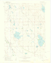
1960 Map of Timnath
USGS Topo · Published 1962About this map
The Timnath Reservoir and Windsor Reservoir anchor this 1960s landscape, illustrating a highly engineered water management system in northern Colorado. The network of the Larimer and Weld Canal and the Boxelder Ditch move water across the Poudre Valley to sustain agriculture in this semi-arid region. Along the Colorado and Southern railroad, the small town of Timnath serves as a local hub, featuring the Timnath Cem and the Boxelder Sch to the northwest.
Find a feature on this map
32 named features on this map. Tap any name to fly to it.
Don’t see what you’re looking for? This feature index may not catch every label — zoom into the map to look around manually.
Map Details
Editions of this 1960 Timnath Map
4 editions found
Other maps of this area

1902 · Greeley
USGS Topo · 1:125,000

1906 · Loveland
USGS Topo · 1:62,500

1906 · Fort Collins
USGS Topo · 1:62,500

1907 · Livermore
USGS Topo · 1:125,000

1908 · Loveland
USGS Topo · 1:62,500

1908 · Fort Collins
USGS Topo · 1:62,500

1908 · Eaton
USGS Topo · 1:125,000

1909 · Livermore
USGS Topo · 1:125,000

1910 · Eaton
USGS Topo · 1:125,000

1950 · Windsor
USGS Topo · 1:24,000