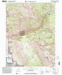
1998 Map of Timpanogos Cave
USGS Topo · Published 2000About this map
Timpanogos Cave National Monument serves as the focal point of this 1998 revision, where the steep canyons of the Wasatch Range meet the expanding residential boundaries of northern Utah County. The landscape is defined by the deep incision of the American Fork river, which flows past the South Fork Ranger Station and through the heart of the Uinta National Forest. To the south, the city limits of Pleasant Grove and Cedar Hills push against the foothills, with the Jordan Aqueduct tracing a vital line of infrastructure through the developed corridor.
Find a feature on this map
46 named features on this map. Tap any name to fly to it.
Don’t see what you’re looking for? This feature index may not catch every label — zoom into the map to look around manually.
Map Details
Editions of this 1998 Timpanogos Cave Map
This is the sole edition of this map. No revisions or reprints were ever made.
Other maps of this area

1885 · Salt Lake
USGS Topo · 1:250,000

1925 · Ft. Douglas
USGS Topo · 1:125,000

1928 · Ft. Douglas
USGS Topo · 1:125,000

1948 · Timpanogos Cave
USGS Topo · 1:24,000

1948 · Orem
USGS Topo · 1:24,000

1948 · Orem
USGS Topo · 1:62,500

1948 · Aspen Grove
USGS Topo · 1:24,000

1948 · Bridal Veil Falls
USGS Topo · 1:24,000

1950 · Orem
USGS Topo · 1:24,000

1950 · Aspen Grove
USGS Topo · 1:24,000