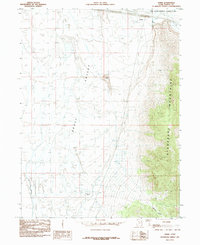
1985 Map of Timpie
USGS Topo · Published 1985About this map
Skull Valley dominates this 1985 landscape, revealing a stark transition between the salt-encrusted basins and the rising heights of the Stansbury Mountains. The map documents the vital role of water management in this arid Tooele County environment, featuring the Timpie Springs Waterfowl Management Area and an extensive Aqueduct system that cuts through the valley floor. Rare reliable water sources like Big Spring and Muskrat Spring are noted along the base of the mountains, providing critical anchor points in a region otherwise defined by expansive Mud Flats and the seasonally inundated Dry Lake. Industrial and infrastructure development is visible through the presence of a Gravel Pit, a Sewage Disposal Pond, and the isolated landmark of Lone Rock, which stands as a sentinel in the northern valley. The descent of Muskrat Canyon into the lowlands illustrates the complex drainage patterns of the eastern range.
Find a feature on this map
13 named features on this map. Tap any name to fly to it.
Don’t see what you’re looking for? This feature index may not catch every label — zoom into the map to look around manually.
Map Details
Editions of this 1985 Timpie Map
This is the sole edition of this map. No revisions or reprints were ever made.
Other maps of this area

1885 · Tooele Valley
USGS Topo · 1:250,000

1953 · Tooele
USGS Topo · 1:250,000

1955 · Timpie
USGS Topo · 1:62,500

1955 · Tooele
USGS Topo · 1:250,000

1968 · Poverty Point
USGS Topo · 1:24,000

1968 · Corral Canyon
USGS Topo · 1:24,000

1973 · Delle
USGS Topo · 1:24,000

1973 · Hastings Pass NE
USGS Topo · 1:24,000
1973 · Hastings Pass SE
USGS Topo · 1:24,000
1979 · Tooele
USGS Topo · 1:100,000