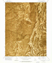
1973 Map of Hastings Pass SE
USGS Topo · Published 1977About this map
Skull Valley dominates this landscape in western Utah, captured here through an orthophotomosaic that reveals the intricate textures of the high desert terrain. The arid environment is characterized by the expansive Mud Flat that stretches across the eastern portion of the sheet, where drainage patterns create complex, braided visual rhythms against the valley floor. In a region where water is the primary limiting factor for any human activity, the presence of a lone Well and a Gravel Pit near the southern boundary suggests the minimal but essential infrastructure supporting ranching or transit through this part of Tooele County. This 1973 field-checked study offers a precise record of the land surface before modern developments, showing a landscape defined by its geological features rather than human settlement.
Find a feature on this map
7 named features on this map. Tap any name to fly to it.
Don’t see what you’re looking for? This feature index may not catch every label — zoom into the map to look around manually.
Map Details
Editions of this 1973 Hastings Pass SE Map
This is the sole edition of this map. No revisions or reprints were ever made.
Other maps of this area

1885 · Tooele Valley
USGS Topo · 1:250,000

1953 · Tooele
USGS Topo · 1:250,000

1955 · Tabbys Peak
USGS Topo · 1:24,000

1955 · Timpie
USGS Topo · 1:62,500

1955 · Deseret Peak
USGS Topo · 1:62,500

1955 · Tooele
USGS Topo · 1:250,000

1973 · Hastings Pass NE
USGS Topo · 1:24,000

1973 · Quincy Spring
USGS Topo · 1:24,000

1973 · Hastings Pass
USGS Topo · 1:24,000

1973 · Hickman Knolls
USGS Topo · 1:24,000