
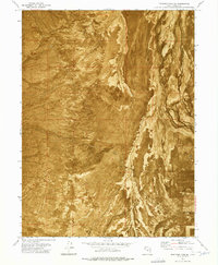
1973 Map of Hickman Knolls
USGS Topo · Published 1977About this map
Skull Valley defines this arid landscape, captured here through a combination of traditional topography and an orthophotomosaic based on 1972 aerial photography. The terrain is characterized by the distinct elevations of the Hickman Knolls and the broad, open expanse of the desert floor. This 1973 field-checked survey highlights the Skull Valley Indian Reservation in the southeastern portion of the quadrangle, providing a rare look at the jurisdictional and physical boundaries of the era. Evidence of water management and local ranching history is present at Hatch Well, situated near the western edge of the valley. The map is particularly useful for understanding the mid-century spatial relationship between tribal lands and the surrounding Tooele County environment.
Find a feature on this map
5 named features on this map. Tap any name to fly to it.
Don’t see what you’re looking for? This feature index may not catch every label — zoom into the map to look around manually.
Map Details
Editions of this 1973 Hickman Knolls Map
This is the sole edition of this map. No revisions or reprints were ever made.
Other maps of this area

1885 · Tooele Valley
USGS Topo · 1:250,000

1953 · Tooele
USGS Topo · 1:250,000

1955 · Tabbys Peak SE
USGS Topo · 1:24,000

1955 · Tabbys Peak
USGS Topo · 1:24,000

1955 · Timpie
USGS Topo · 1:62,500

1955 · Deseret Peak
USGS Topo · 1:62,500

1955 · Tabbys Peak SW
USGS Topo · 1:24,000

1955 · Tooele
USGS Topo · 1:250,000

1973 · Quincy Spring
USGS Topo · 1:24,000
1973 · Hastings Pass SE
USGS Topo · 1:24,000