
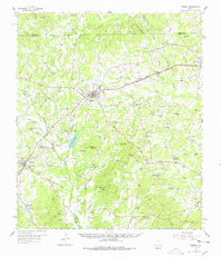
1958 Map of Timpson
USGS Topo · Published 1959About this map
Timpson serves as the focal point of this late 1950s survey of East Texas, where the intersection of the Texas and New Orleans RR and the Gulf Colorado and Santa Fe RR shaped local commerce. The landscape is a network of small rural communities and named water bodies like Lake Timpson and the meandering Attoyac Bayou. Significant for genealogists, the map identifies numerous country churches and cemeteries, including Todd Spring Ch, Mt Gideon Cem, and Greenwood Cem, which anchor the surrounding farmstead regions. Topographically, the area is defined by low-lying ridges such as Bennett Mtn and Hallow Rock Mtn. To the southwest, the town of Garrison sits near the crossing of Lick Creek and Jenks Creek, while scattered Oil Wells and a Gas Well indicate the period's active petroleum exploration across the county lines.
Find a feature on this map
81 named features on this map. Tap any name to fly to it.
Don’t see what you’re looking for? This feature index may not catch every label — zoom into the map to look around manually.
Map Details
Editions of this 1958 Timpson Map
2 editions found
Other maps of this area

1945 · Socagee Bayou
USGS Topo · 1:62,500

1952 · Nacogdoches
USGS Topo · 1:62,500

1953 · Palestine
USGS Topo · 1:250,000

1956 · Tyler
USGS Topo · 1:250,000

1956 · Deadwood
USGS Topo · 1:62,500

1957 · Palestine
USGS Topo · 1:250,000

1958 · Center
USGS Topo · 1:62,500

1958 · San Augustine
USGS Topo · 1:62,500

1958 · Martinsville
USGS Topo · 1:62,500

1958 · Carthage
USGS Topo · 1:62,500