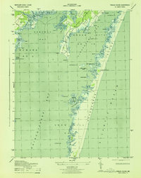
1943 Map of Tingles Island
USGS Topo · Published 1943About this map
Assateague Island and the complex salt marshes of Worcester County define this 1943 coastal survey. Published during the war years, the map documents a landscape of intricate waterways and sandy points before significant modern development altered the shoreline. The barrier island serves as a buffer for Chincoteague Bay, Sinepuxent Bay, and Newport Bay, creating a sheltered environment for features like Tingles Island and Tingles Narrows.
Find a feature on this map
44 named features on this map. Tap any name to fly to it.
Don’t see what you’re looking for? This feature index may not catch every label — zoom into the map to look around manually.
Map Details
Editions of this 1943 Tingles Island Map
This is the sole edition of this map. No revisions or reprints were ever made.
Other maps of this area

1901 · Snow Hill
USGS Topo · 1:62,500

1901 · Green Run
USGS Topo · 1:62,500

1901 · Ocean City
USGS Topo · 1:62,500

1902 · Pittsville
USGS Topo · 1:62,500

1938 · Green Run
USGS Topo · 1:62,500

1942 · Ocean City
USGS Topo · 1:62,500

1942 · Ninepin
USGS Topo · 1:24,000

1942 · Ocean City
USGS Topo · 1:24,000

1942 · Tingles Island
USGS Topo · 1:24,000

1942 · Wesley
USGS Topo · 1:24,000