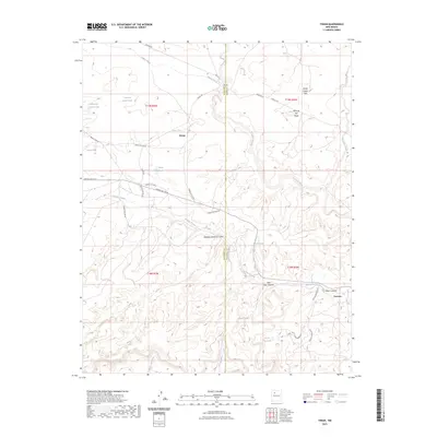
2023 Map of Tinian
USGS Topo · Published 2023About this map
Tinian and the surrounding high desert of the McKinley and Sandoval county line are defined by a complex network of arroyos and canyons in this 2023 survey. The landscape is marked by the infrastructure of livestock ranching and resource extraction, featuring numerous water catchments like Uranium Claim Tank and Homestead Corner Tank. The terrain transitions from the high ground of Mesa de San Felipe and Sheep Queen Hill down into deep incisions such as Noberto Sandoval Cañon and Piñon Canyon.
Find a feature on this map
35 named features on this map. Tap any name to fly to it.
Don’t see what you’re looking for? This feature index may not catch every label — zoom into the map to look around manually.
Map Details
Editions of this 2023 Tinian Map
This is the sole edition of this map. No revisions or reprints were ever made.
Other maps of this area

1883 · Mt. Taylor
USGS Topo · 1:250,000

1886 · Mt. Taylor
USGS Topo · 1:250,000

1892 · Mt. Taylor
USGS Topo · 1:250,000

1899 · Mt. Taylor
USGS Topo · 1:250,000

1958 · Albuquerque
USGS Topo · 1:250,000
1961 · Ojo Encino Mesa
USGS Topo · 1:24,000
1961 · Johnson Trading Post
USGS Topo · 1:24,000
1961 · Star Lake
USGS Topo · 1:24,000

1961 · Mesita Del Gavilan
USGS Topo · 1:24,000

1961 · Arroyo Empedrado
USGS Topo · 1:24,000
Featured Places
- Eastern Navajo Agency, NM
- Tinian, Eastern Navajo Agency
- Sandoval County, NM
- McKinley County, NM
- United States