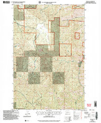
2003 Map of Tiptop
USGS Topo · Published 2006About this map
Wenatchee National Forest encompasses a landscape defined by deep canyons and seasonal watercourses in this early 21st-century survey of the Chelan region. The high ground of Tronsen Ridge and the peak of Tiptop overlook a network of drainages including Mission Creek, Sand Creek, and Brender Canyon. A notable geographical feature is the Camas Land plateau, where the terrain levels out before dropping toward the surrounding creek beds. Evidence of modern infrastructure is sparse, limited primarily to a Quarry and a Communication Tower near the summit of Tiptop. The map documents the intricate drainage patterns of the Wenatchee National Forest just after the turn of the millennium, following a 2003 revision that updated forest boundaries and public land survey systems. Features like Deer Park Spring and Little Camas Creek highlight the essential water sources that have historically shaped land use in this part of Washington.
Find a feature on this map
21 named features on this map. Tap any name to fly to it.
Don’t see what you’re looking for? This feature index may not catch every label — zoom into the map to look around manually.
Map Details
Editions of this 2003 Tiptop Map
This is the sole edition of this map. No revisions or reprints were ever made.
Other maps of this area

1897 · Mount Stuart
USGS Topo · 1:125,000

1901 · Chelan
USGS Topo · 1:125,000

1901 · Chiwaukum
USGS Topo · 1:125,000

1902 · Mount Stuart
USGS Topo · 1:125,000

1904 · Chiwaukum
USGS Topo · 1:125,000

1913 · Wenatchee
USGS Topo · 1:62,500

1915 · Wenatchee
USGS Topo · 1:62,500

1920 · Colockum Pass
USGS Topo · 1:125,000

1922 · Colockum Pass
USGS Topo · 1:125,000

1957 · Wenatchee
USGS Topo · 1:250,000