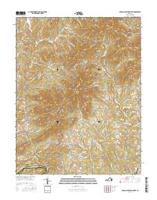
2016 Map of Tobacco Row Mountain
USGS Topo · Published 2016About this map
Tobacco Row Mtn High Peak dominates this landscape in Amherst County, where the topography transitions from the higher elevations of Love Lady Mtn and Gun Mtn toward the southern boundary along the James River. Small settlements such as Elon, Agricola, and Pleasant View are connected by a network of winding roads, including the Buffalo Springs Tpke, which traces the contours of the land.
Find a feature on this map
125 named features on this map. Tap any name to fly to it.
Don’t see what you’re looking for? This feature index may not catch every label — zoom into the map to look around manually.
Map Details
Editions of this 2016 Tobacco Row Mountain Map
This is the sole edition of this map. No revisions or reprints were ever made.
Other maps of this area

1892 · Lynchburg
USGS Topo · 1:125,000

1894 · Lexington
USGS Topo · 1:125,000

1935 · Buena Vista
USGS Topo · 1:48,000

1935 · Amherst
USGS Topo · 1:48,000

1939 · Amherst
USGS Topo · 1:62,500

1939 · Buena Vista
USGS Topo · 1:62,500

1940 · Buena Vista
USGS Topo · 1:62,500

1944 · Lynchburg
USGS Topo · 1:62,500

1947 · Roanoke
USGS Topo · 1:250,000

1950 · Goode
USGS Topo · 1:62,500