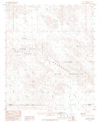
1986 Map of Tom Thumb
USGS Topo · Published 1986About this map
The Sauceda Mountains dominate this high-desert landscape in the mid-1980s, where the peaks of Tom Thumb and the passage at Pistol Pass overlook a complex network of arid drainage systems. This area is defined by its administrative and natural boundaries, sitting at the junction of the Luke Air Force Range and the Papago Indian Reservation. The terrain is deeply etched by numerous seasonal watercourses, including Sauceda Wash and Hickiwan Wash, which feed into the broad Hickiwan Valley at the southern edge of the sheet. The map also records the county line where Maricopa Co meets Pima Co, providing a clear record of land use and division in this remote section of the Sonoran desert during the late twentieth century.
Find a feature on this map
12 named features on this map. Tap any name to fly to it.
Don’t see what you’re looking for? This feature index may not catch every label — zoom into the map to look around manually.
Map Details
Editions of this 1986 Tom Thumb Map
This is the sole edition of this map. No revisions or reprints were ever made.
Other maps of this area

1953 · Ajo
USGS Topo · 1:250,000

1957 · Ajo
USGS Topo · 1:250,000

1958 · Ajo
USGS Topo · 1:250,000

1958 · Kaka
USGS Topo · 1:62,500

1958 · Hat Mountain
USGS Topo · 1:62,500

1962 · Ajo
USGS Topo · 1:250,000

1963 · Ajo
USGS Topo · 1:250,000

1963 · Sikort Chuapo Mts
USGS Topo · 1:62,500

1963 · Cimarron Peak
USGS Topo · 1:62,500

1967 · Ajo
USGS Topo · 1:250,000