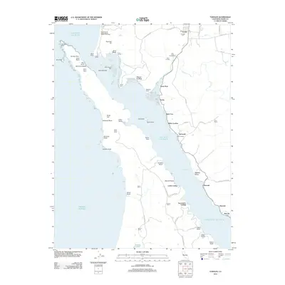
2012 Map of Tomales
USGS Topo · Published 2012About this map
Tomales Bay dominates this coastal survey, where the interface of land and sea is defined by small maritime landings and historic dairy ranches. On the eastern shore, tiny settlements like Marshall, Hamlet, and Cypress Grove line the water's edge, while the western peninsula is marked by a series of family-named agricultural holdings including Lower Pierce Ranch, Kehoe Ranch, and McClure Ranch. These ranching sites, alongside prominent geographic features like Tomales Point and Tomales Bluff, illustrate a landscape that has long balanced coastal industry with rugged isolation. Educational and commercial infrastructure is visible at the University of Pacific Marine Station of Biology and the town of Tomales itself, which serves as the inland anchor for this stretch of the Marin coast. The map also records numerous beach access points such as McClures Beach and Avals Beach, reflecting the region's enduring character as a site for both labor and leisure.
Find a feature on this map
71 named features on this map. Tap any name to fly to it.
Don’t see what you’re looking for? This feature index may not catch every label — zoom into the map to look around manually.
Map Details
Editions of this 2012 Tomales Map
This is the sole edition of this map. No revisions or reprints were ever made.
Other maps of this area

1916 · Point Reyes
USGS Topo · 1:48,000

1918 · Point Reyes
USGS Topo · 1:62,500

1935 · Sebastopol
USGS Topo · 1:48,000

1942 · Sebastopol
USGS Topo · 1:62,500

1942 · Bodega Head
USGS Topo · 1:24,000

1944 · Bodega Head
USGS Topo · 1:31,680

1947 · Santa Rosa
USGS Topo · 1:250,000

1949 · Santa Rosa
USGS Topo · 1:250,000

1953 · Drakes Bay
USGS Topo · 1:24,000
1954 · Two Rock
USGS Topo · 1:24,000