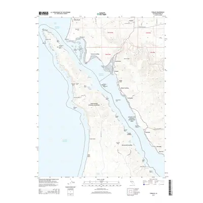
2015 Map of Tomales
USGS Topo · Published 2015About this map
Tomales sits inland from the head of the inlet, serving as a primary hub in this coastal landscape of West Marin. The topography is defined by the long, linear basin of the San Andreas Fault, which creates the distinct northwest-to-southeast alignment of the waterway. Coastal life is centered around a series of historic points and coves, including Vincent Landing, Blakes Landing, and Marshall. These locations reflect a long history of maritime and dairy transport, while larger protected areas like the Point Reyes National Seashore and Golden Gate National Recreation Area preserve the natural character of the shoreline. From the northern reaches of Dillon Beach to the inlets of Hearts Desire, the map reveals a rugged coastal economy transitioning into a landscape of conservation and recreation.
Find a feature on this map
68 named features on this map. Tap any name to fly to it.
Don’t see what you’re looking for? This feature index may not catch every label — zoom into the map to look around manually.
Map Details
Editions of this 2015 Tomales Map
This is the sole edition of this map. No revisions or reprints were ever made.
Other maps of this area

1916 · Point Reyes
USGS Topo · 1:48,000

1918 · Point Reyes
USGS Topo · 1:62,500

1935 · Sebastopol
USGS Topo · 1:48,000

1942 · Sebastopol
USGS Topo · 1:62,500

1942 · Bodega Head
USGS Topo · 1:24,000

1944 · Bodega Head
USGS Topo · 1:31,680

1947 · Santa Rosa
USGS Topo · 1:250,000

1949 · Santa Rosa
USGS Topo · 1:250,000

1953 · Drakes Bay
USGS Topo · 1:24,000
1954 · Two Rock
USGS Topo · 1:24,000