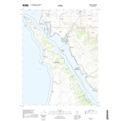
2018 Map of Tomales
USGS Topo · Published 2018About this map
Tomales serves as the inland anchor for this coastal survey, where the Tomales Petaluma Rd and Dillon Beach Rd intersect near the Tomales Cem. The landscape is defined by the long, narrow reach of Tomales Bay, separating the mainland from the protected expanse of the Point Reyes National Seashore. Small coastal settlements and landings like Cypress Grove, Marshall, and Marconi line the eastern shore of the bay, while the western side is dominated by the ridges of the peninsula, including Inverness Ridge and the heights above McClures Beach.
Find a feature on this map
65 named features on this map. Tap any name to fly to it.
Don’t see what you’re looking for? This feature index may not catch every label — zoom into the map to look around manually.
Map Details
Editions of this 2018 Tomales Map
This is the sole edition of this map. No revisions or reprints were ever made.
Other maps of this area

1916 · Point Reyes
USGS Topo · 1:48,000

1918 · Point Reyes
USGS Topo · 1:62,500

1935 · Sebastopol
USGS Topo · 1:48,000

1942 · Sebastopol
USGS Topo · 1:62,500

1942 · Bodega Head
USGS Topo · 1:24,000

1944 · Bodega Head
USGS Topo · 1:31,680

1947 · Santa Rosa
USGS Topo · 1:250,000

1949 · Santa Rosa
USGS Topo · 1:250,000

1953 · Drakes Bay
USGS Topo · 1:24,000
1954 · Two Rock
USGS Topo · 1:24,000