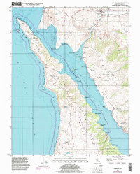
1995 Map of Tomales
USGS Topo · Published 1998About this map
The San Andreas Rift Zone forms the dominant geological spine of this coastal landscape, creating the linear trough of Tomales Bay that separates the mainland from the Tomales Point peninsula. This 1990s record of western Marin County highlights a rural economy rooted in coastal ranching and aquaculture, with numerous historic family holdings such as Upper Pierce Ranch, Lower Pierce Ranch, and Kehoe Ranch dotting the interior hills. Along the eastern shore, small settlements and landings like Marshall, Hamlet, and Lairds Landing are linked by the old Railroad grade and Walker Creek. The map also preserves details of local education and industry, from the Joint Union High Sch in Tomales to the active Oyster Pen operations and the University of Pacific Marine Station of Biological Science near Dillon Beach.
Find a feature on this map
52 named features on this map. Tap any name to fly to it.
Don’t see what you’re looking for? This feature index may not catch every label — zoom into the map to look around manually.
Map Details
Editions of this 1995 Tomales Map
This is the sole edition of this map. No revisions or reprints were ever made.
Other maps of this area

1916 · Point Reyes
USGS Topo · 1:48,000

1918 · Point Reyes
USGS Topo · 1:62,500

1935 · Sebastopol
USGS Topo · 1:48,000

1942 · Sebastopol
USGS Topo · 1:62,500

1942 · Bodega Head
USGS Topo · 1:24,000

1944 · Bodega Head
USGS Topo · 1:31,680

1947 · Santa Rosa
USGS Topo · 1:250,000

1949 · Santa Rosa
USGS Topo · 1:250,000

1953 · Drakes Bay
USGS Topo · 1:24,000
1954 · Two Rock
USGS Topo · 1:24,000