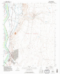
1991 Map of Tome
USGS Topo · Published 1996About this map
The Rio Grande valley south of Albuquerque is defined here by an intricate network of irrigation and drainage infrastructure supporting long-established settlements. Communities like Tome, El Cerro, and La Constancia are situated between the river and the rising eastern terrain, their footprints intertwined with the Peralta Main Canal, Tome Ditch, and La Constancia Lateral. This 1991 revision reflects the deep historical roots of the area, specifically within the boundaries of the Nicolas Duran de Chavez Grant and the Tome Grant. Genealogists will find the Tome Cemetery centrally located near the foothills, while the southern reach of the map transitions into the public lands of Senator Willie M Chavez State Park. The landscape is a stark study in New Mexico water management, contrasting the lush river bottom with the arid drainage of La Cañada de la Loma de Arena and various livestock tanks to the east.
Find a feature on this map
31 named features on this map. Tap any name to fly to it.
Don’t see what you’re looking for? This feature index may not catch every label — zoom into the map to look around manually.
Map Details
Editions of this 1991 Tome Map
This is the sole edition of this map. No revisions or reprints were ever made.
Other maps of this area

1952 · Dalies
USGS Topo · 1:24,000

1952 · Tome SE
USGS Topo · 1:24,000

1952 · Tome NE
USGS Topo · 1:24,000

1952 · Belen
USGS Topo · 1:24,000

1952 · Turn
USGS Topo · 1:24,000

1952 · Veguita
USGS Topo · 1:24,000

1952 · Tome
USGS Topo · 1:24,000

1952 · Los Lunas SE
USGS Topo · 1:24,000

1952 · Los Lunas
USGS Topo · 1:24,000

1954 · Socorro
USGS Topo · 1:250,000