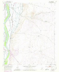
1952 Map of Tome
USGS Topo · Published 1980About this map
The Tome Grant and its agricultural valley define the landscape of this 1952 survey, showcasing an intricate network of irrigation and drainage infrastructure along the Rio Grande. Settlements like Tome and Adelino are tied closely to the river's path, supported by the Peralta Main Canal and the Tome Ditch. The map illustrates the transition from the fertile river bottom to the high desert terrain of the Loma de Arena and La Loma Alta. Local history is anchored by the Tome Cemetery and Adelino School, while the presence of the At & SF railroad and an Oil Well (Aban'd) reflect the industrial and transport ties of mid-century Valencia County. Small clusters such as La Constancia and La Ladera are mapped in detail, revealing the persistent land grant boundaries that have shaped New Mexico's social and physical geography for generations.
Find a feature on this map
34 named features on this map. Tap any name to fly to it.
Don’t see what you’re looking for? This feature index may not catch every label — zoom into the map to look around manually.
Map Details
Editions of this 1952 Tome Map
3 editions found
Other maps of this area

1952 · Dalies
USGS Topo · 1:24,000

1952 · Tome SE
USGS Topo · 1:24,000

1952 · Tome NE
USGS Topo · 1:24,000

1952 · Belen
USGS Topo · 1:24,000

1952 · Turn
USGS Topo · 1:24,000

1952 · Veguita
USGS Topo · 1:24,000

1952 · Tome
USGS Topo · 1:24,000

1952 · Los Lunas SE
USGS Topo · 1:24,000

1952 · Los Lunas
USGS Topo · 1:24,000

1954 · Socorro
USGS Topo · 1:250,000