
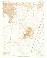
1952 Map of Dalies
USGS Topo · Published 1953About this map
El Cerro de los Lunas dominates the central landscape of this New Mexico quadrangle, surrounded by the remnants of prehistoric lava flows. The area is defined by complex land grant boundaries, including the San Clemente Grant and the Nicolas Duran de Chavez Grant, reflecting the region's deep Hispanic and Pueblo heritage. Along the western edge, the Atchison Topeka and Santa Fe railroad intersects at Dalies, a critical junction for the Belen High Line. Water management is evident in the southeastern corner near Los Lunas, where the Los Lunas Wasteway and several irrigation ditches like the Gabaldon Lateral support the local agriculture and the New Mexico Penitentiary Farm. Small settlements such as Paquita and Sandia appear along the rail lines, while resource exploration is marked by the Dallies Oil Well (Aband).
Find a feature on this map
26 named features on this map. Tap any name to fly to it.
Don’t see what you’re looking for? This feature index may not catch every label — zoom into the map to look around manually.
Map Details
Editions of this 1952 Dalies Map
2 editions found
Other maps of this area

1952 · Wind Mesa
USGS Topo · 1:24,000

1952 · Belen
USGS Topo · 1:24,000

1952 · Belen NW
USGS Topo · 1:24,000

1952 · Rio Puerco
USGS Topo · 1:24,000

1952 · Tome
USGS Topo · 1:24,000

1952 · Los Lunas
USGS Topo · 1:24,000

1952 · Isleta
USGS Topo · 1:24,000

1952 · Dalies NW
USGS Topo · 1:24,000

1954 · Socorro
USGS Topo · 1:250,000

1958 · Socorro
USGS Topo · 1:250,000