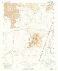
1952 Map of Dalies
USGS Topo · Published 1973About this map
Ancient volcanic geography meets New Mexico's complex land-grant history in this 1952 topographic study. The landscape is dominated by the prominent volcanic mass of El Cerro de los Lunas, surrounded by extensive lava fields to the north. These geological features are overlaid by a intricate map of historical land boundaries, including the Isleta Pueblo Grant and the San Clemente Grant, reflecting centuries of land tenure.
Find a feature on this map
24 named features on this map. Tap any name to fly to it.
Don’t see what you’re looking for? This feature index may not catch every label — zoom into the map to look around manually.
Map Details
Editions of this 1952 Dalies Map
2 editions found
Other maps of this area

1952 · Wind Mesa
USGS Topo · 1:24,000

1952 · Dalies
USGS Topo · 1:24,000

1952 · Belen
USGS Topo · 1:24,000

1952 · Belen NW
USGS Topo · 1:24,000

1952 · Rio Puerco
USGS Topo · 1:24,000

1952 · Tome
USGS Topo · 1:24,000

1952 · Los Lunas
USGS Topo · 1:24,000

1952 · Isleta
USGS Topo · 1:24,000

1952 · Dalies NW
USGS Topo · 1:24,000

1954 · Socorro
USGS Topo · 1:250,000