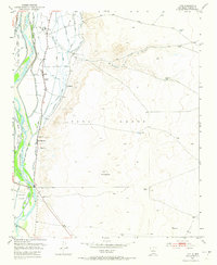
1952 Map of Tome
USGS Topo · Published 1973About this map
Rio Grande waters dominate the western valley of this Rio Abajo landscape, where an intricate network of irrigation infrastructure supported the traditional agricultural communities of the Tome Grant. Settled long before this 1952 survey, the area is defined by its system of acequias and drains, including the Peralta Main Canal and the Tome Ditch, which parallel the river's course. These waterways enabled the development of clusters like Tome and Adelino, where the Adelino School and Tome Cemetery served the local families. East of the fertile valley, the terrain rises sharply toward Loma de Arena and the open range of La Loma Alta, punctuated by solitary landmarks like El Grande Tank. The arrival of the At & SF railroad and state highways provided vital connections to the larger trade centers of the valley while maintaining the distinct boundaries of historical land grants like the Belen Grant and the Chavez Grant.
Find a feature on this map
40 named features on this map. Tap any name to fly to it.
Don’t see what you’re looking for? This feature index may not catch every label — zoom into the map to look around manually.
Map Details
Editions of this 1952 Tome Map
3 editions found
Other maps of this area

1952 · Dalies
USGS Topo · 1:24,000

1952 · Tome SE
USGS Topo · 1:24,000

1952 · Tome NE
USGS Topo · 1:24,000

1952 · Belen
USGS Topo · 1:24,000

1952 · Turn
USGS Topo · 1:24,000

1952 · Veguita
USGS Topo · 1:24,000

1952 · Tome
USGS Topo · 1:24,000

1952 · Los Lunas SE
USGS Topo · 1:24,000

1952 · Los Lunas
USGS Topo · 1:24,000

1954 · Socorro
USGS Topo · 1:250,000