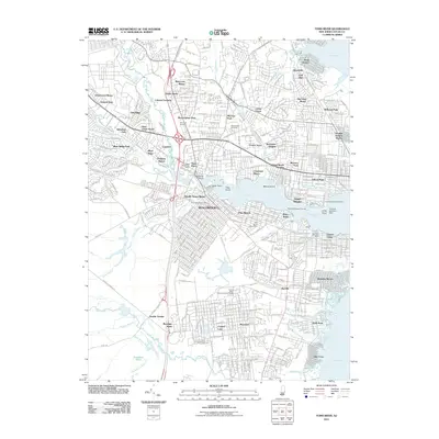
2011 Map of Toms River
USGS Topo · Published 2011About this map
The tidal waters of Toms River and its confluence with Barnegat Bay define this coastal landscape, which serves as a nexus for numerous residential developments and maritime activity. The map illustrates a dense network of suburban neighborhoods, including Silver Ridge Park, Manitou Park, and Gilford Park, which established themselves around the central artery of the Garden State Pkwy. While modern infrastructure dominates the uplands, the shoreline retains specific historical markers of the Jersey Shore economy, such as the Hummel Seaplane Base near Long Point.
Find a feature on this map
73 named features on this map. Tap any name to fly to it.
Don’t see what you’re looking for? This feature index may not catch every label — zoom into the map to look around manually.
Map Details
Editions of this 2011 Toms River Map
This is the sole edition of this map. No revisions or reprints were ever made.
Other maps of this area

1884 · Whitings
USGS Topo · 1:62,500

1888 · Barnegat
USGS Topo · 1:62,500

1888 · Asbury Park
USGS Topo · 1:62,500

1888 · Cassville
USGS Topo · 1:62,500

1888 · Whitings
USGS Topo · 1:62,500

1893 · Asbury Park
USGS Topo · 1:62,500

1893 · Barnegat
USGS Topo · 1:62,500

1894 · Cassville
USGS Topo · 1:62,500

1898 · Barnegat
USGS Topo · 1:62,500

1900 · Cassville
USGS Topo · 1:62,500