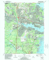
1989 Map of Toms River
USGS Topo · Published 1989About this map
Toms River and its surrounding communities are shown here in the late 1980s, revealing a landscape defined by its coastal inlets and rapid suburban expansion. The residential growth is evident in developments like Silver Ridge Park and Oak Ridge Estates, which sit alongside the legacy of older transit lines like the Central Railroad of New Jersey. The map illustrates a transition from the marshy lowlands of Double Trouble State Park to the developed shorelines of Island Heights and Beachwood. Along the water, landmarks such as the Admiral Farragut Academy and Toms River Country Club reflect the area's established social and educational institutions. Further south, the map details the intricate waterways of Barnegat Bay, including Clamming Creek and Sloop Creek, while inland, numerous Cranberry Bogs and the quiet waters of Crystal Lake point to the region's agricultural roots and recreational focus.
Find a feature on this map
116 named features on this map. Tap any name to fly to it.
Don’t see what you’re looking for? This feature index may not catch every label — zoom into the map to look around manually.
Map Details
Editions of this 1989 Toms River Map
This is the sole edition of this map. No revisions or reprints were ever made.
Other maps of this area

1884 · Whitings
USGS Topo · 1:62,500

1888 · Barnegat
USGS Topo · 1:62,500

1888 · Asbury Park
USGS Topo · 1:62,500

1888 · Cassville
USGS Topo · 1:62,500

1888 · Whitings
USGS Topo · 1:62,500

1893 · Asbury Park
USGS Topo · 1:62,500

1893 · Barnegat
USGS Topo · 1:62,500

1894 · Cassville
USGS Topo · 1:62,500

1898 · Barnegat
USGS Topo · 1:62,500

1900 · Cassville
USGS Topo · 1:62,500