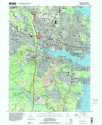
1995 Map of Toms River
USGS Topo · Published 2001About this map
Toms River and its surrounding coastal communities are captured here in the mid-1990s, showcasing a landscape defined by the intersection of the Garden State Parkway and the sprawling waterways of Barnegat Bay. The map highlights the area's transition from the dense residential developments of Oak Ridge Estates and Silver Ridge Park to the preserved natural wetlands and Cranberry Bogs found within Double Trouble State Park.
Find a feature on this map
76 named features on this map. Tap any name to fly to it.
Don’t see what you’re looking for? This feature index may not catch every label — zoom into the map to look around manually.
Map Details
Editions of this 1995 Toms River Map
This is the sole edition of this map. No revisions or reprints were ever made.
Other maps of this area

1884 · Whitings
USGS Topo · 1:62,500

1888 · Barnegat
USGS Topo · 1:62,500

1888 · Asbury Park
USGS Topo · 1:62,500

1888 · Cassville
USGS Topo · 1:62,500

1888 · Whitings
USGS Topo · 1:62,500

1893 · Asbury Park
USGS Topo · 1:62,500

1893 · Barnegat
USGS Topo · 1:62,500

1894 · Cassville
USGS Topo · 1:62,500

1898 · Barnegat
USGS Topo · 1:62,500

1900 · Cassville
USGS Topo · 1:62,500