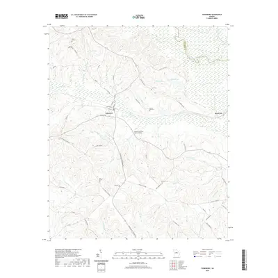
2020 Map of Toomsboro
USGS Topo · Published 2020About this map
Toomsboro serves as the primary hub in this Georgia landscape, situated where the S Railroad St corridor meets the meandering path of Commissioner Cr. The geography is defined by a dense network of tributaries flowing toward the Oconee River, which forms the boundary with Washington County to the northeast. This area is notably dense with family and community burial sites, including the David Clay Cem, Poplar Springs Cem, and the Stevens-Cason Cem, offering significant value for genealogical research. The landscape transitions from the residential streets of Jefferson St and Main St into a rural expanse marked by Buckhorn Lake and the William H Freeman Memorial Bridge crossing Camp Cr. Smaller localities like Beech Hill anchor the eastern reaches of the quadrangle among the various branches and creeks.
Find a feature on this map
61 named features on this map. Tap any name to fly to it.
Don’t see what you’re looking for? This feature index may not catch every label — zoom into the map to look around manually.
Map Details
Editions of this 2020 Toomsboro Map
This is the sole edition of this map. No revisions or reprints were ever made.
Other maps of this area

1916 · Irwinton
USGS Topo · 1:62,500

1920 · Irwinton
USGS Topo · 1:62,500

1957 · Macon
USGS Topo · 1:250,000

1958 · Macon
USGS Topo · 1:250,000

1962 · Oconee
USGS Topo · 1:24,000

1962 · Tabernacle
USGS Topo · 1:24,000

1964 · Macon
USGS Topo · 1:250,000
1973 · Napier Pond
USGS Topo · 1:24,000
1973 · Irwinton
USGS Topo · 1:24,000
1973 · Toomsboro
USGS Topo · 1:24,000