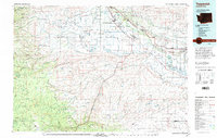
1979 Map of Toppenish
USGS Topo · Published 1997About this map
Fort Simcoe Historical State Park stands as a focal point of early regional history within the expansive Yakima Indian Reservation, where the landscape transitions from the high peaks of Simcoe Mountain to the agricultural valleys of the Yakima River. By the late 1970s, the irrigation network including the Toppenish Canal and Sunnyside Canal had deeply shaped the local economy, supporting a string of settlements from Wapato and Toppenish to Sunnyside. The map illustrates a complex intersection of transportation and conservation, featuring the Burlington Northern railroad lines running parallel to the river and the protected lands of the Toppenish National Wildlife Refuge. From the northern Rattlesnake Hills to the southern Horse Heaven ridge, the terrain is marked by numerous named canyons like Coyote Canyon and Island Canyon, providing a detailed look at the geographical barriers that directed the path of development in Yakima and Klickitat counties.
Find a feature on this map
82 named features on this map. Tap any name to fly to it.
Don’t see what you’re looking for? This feature index may not catch every label — zoom into the map to look around manually.
Map Details
Editions of this 1979 Toppenish Map
2 editions found
Other maps of this area

1899 · Ellensburg
USGS Topo · 1:125,000

1901 · Ellensburg
USGS Topo · 1:125,000

1902 · Mount Aix
USGS Topo · 1:125,000

1904 · Mt Aix
USGS Topo · 1:125,000

1904 · Mount Adams
USGS Topo · 1:125,000

1906 · Blalock Island
USGS Topo · 1:125,000

1907 · Mount Adams
USGS Topo · 1:125,000

1908 · Blalock Island
USGS Topo · 1:125,000

1910 · Zillah
USGS Topo · 1:125,000

1915 · Prosser
USGS Topo · 1:125,000