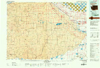
1979 Map of Toppenish
USGS Topo · Published 1979About this map
The Yakima Indian Reservation dominates this central Washington landscape, where the fertile Yakima Valley meets a series of dramatic ridges. The Yakima River serves as a vital corridor, supporting a string of agricultural and rail-oriented settlements including Toppenish, Wapato, and Sunnyside. The map details the complex irrigation and drainage patterns essential to this arid region's economy, with the Burlington Northern railroad providing the critical link between these valley towns and broader markets.
Find a feature on this map
61 named features on this map. Tap any name to fly to it.
Don’t see what you’re looking for? This feature index may not catch every label — zoom into the map to look around manually.
Map Details
Editions of this 1979 Toppenish Map
2 editions found
Other maps of this area

1899 · Ellensburg
USGS Topo · 1:125,000

1901 · Ellensburg
USGS Topo · 1:125,000

1902 · Mount Aix
USGS Topo · 1:125,000

1904 · Mt Aix
USGS Topo · 1:125,000

1904 · Mount Adams
USGS Topo · 1:125,000

1906 · Blalock Island
USGS Topo · 1:125,000

1907 · Mount Adams
USGS Topo · 1:125,000

1908 · Blalock Island
USGS Topo · 1:125,000

1910 · Zillah
USGS Topo · 1:125,000

1915 · Prosser
USGS Topo · 1:125,000