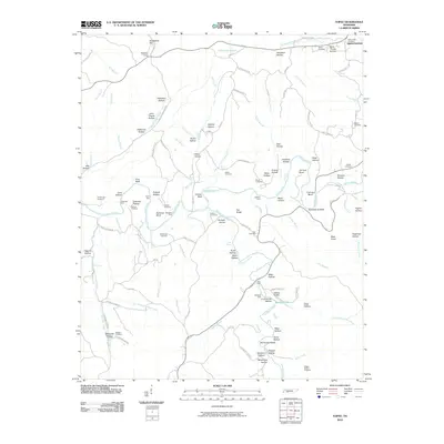
2010 Map of Topsy
USGS Topo · Published 2010About this map
Buffalo River and Fortyeight Creek define the drainage of this Wayne County landscape, where deep hollows and high ridges have shaped decades of rural settlement. The terrain is marked by numerous family-named landmarks such as John Thorpe Hollow, Robinson Hollow, and Durham Hollow, alongside local burial grounds like Whitehead Cemetery and Skelton Cemetery. A unique geological feature, the Natural Bridge, sits near the southern bend of Fortyeight Creek alongside Rainbow Lake. The map reveals the persistence of early river crossings, noting several traditional points such as Kelly Ford, Stockard Ford, and Carey Ford. While the community of Sweetwater anchors the northeast corner, the rest of the sheet is a network of ridge roads and valley tracks, including Topsy Rd and Seiber Ridge Rd, connecting timbered hills and small creek bottomlands. Exploration of the southern ridges shows historical resource extraction via the Dugger Hollow Prospects.
Find a feature on this map
122 named features on this map. Tap any name to fly to it.
Don’t see what you’re looking for? This feature index may not catch every label — zoom into the map to look around manually.
Map Details
Editions of this 2010 Topsy Map
This is the sole edition of this map. No revisions or reprints were ever made.
Other maps of this area

1905 · Waynesboro
USGS Topo · 1:125,000

1936 · Riverside
USGS Topo · 1:24,000

1936 · Graves Spring
USGS Topo · 1:24,000

1936 · Linden
USGS Topo · 1:24,000

1936 · Leatherwood
USGS Topo · 1:24,000

1936 · Negro Hollow
USGS Topo · 1:24,000

1936 · Kimmins
USGS Topo · 1:24,000

1936 · Waynesboro
USGS Topo · 1:24,000

1936 · Topsy
USGS Topo · 1:24,000

1936 · Ovilla
USGS Topo · 1:24,000