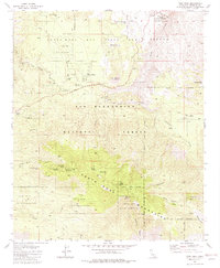
1981 Map of Toro Peak
USGS Topo · Published 1982About this map
Santa Rosa Mountains and high desert plateaus dominate this 1980s landscape, where small residential pockets like Alpine Village and Pinyon Pines sit at the transition between the San Bernardino National Forest and the Santa Rosa Indian Reservation. The geography is defined by significant elevation changes, rising to summits at Santa Rosa Mountain and Toro Peak, which includes a Radio Facility Heliport.
Find a feature on this map
51 named features on this map. Tap any name to fly to it.
Don’t see what you’re looking for? This feature index may not catch every label — zoom into the map to look around manually.
Map Details
Editions of this 1981 Toro Peak Map
3 editions found
Other maps of this area

1901 · Southern California Sheet No. 1
USGS Topo · 1:250,000

1901 · San Jacinto
USGS Topo · 1:125,000

1903 · Ramona
USGS Topo · 1:125,000

1904 · Indio
USGS Topo · 1:125,000

1904 · Southern California Sheet No. 2
USGS Topo · 1:250,000

1904 · Southern California Sheet No. 1
USGS Topo · 1:250,000

1931 · Vallecito
USGS Topo · 1:125,000

1939 · Warner Springs
USGS Topo · 1:62,500

1940 · Hemet Reservoir
USGS Topo · 1:62,500

1941 · Toro Peak
USGS Topo · 1:62,500