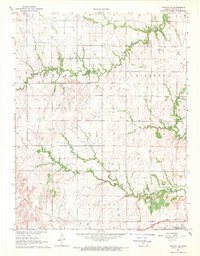
1968 Map of Toronto NE
USGS Topo · Published 1969About this map
Oil Field activity and scattered agricultural landmarks define this Woodson County landscape during the late 1960s. The terrain is partitioned into North, Liberty, and Center townships, where the winding courses of Turkey Creek and Owl Creek dictate the placement of local infrastructure. Small pockets of industry are visible through numerous Oil Wells and a Gravel Pit, while the southern edge is traced by the Missouri Pacific railroad line.
Find a feature on this map
13 named features on this map. Tap any name to fly to it.
Don’t see what you’re looking for? This feature index may not catch every label — zoom into the map to look around manually.
Map Details
Editions of this 1968 Toronto NE Map
This is the sole edition of this map. No revisions or reprints were ever made.
Other maps of this area

1885 · Burlington
USGS Topo · 1:125,000

1886 · Fredonia
USGS Topo · 1:125,000

1894 · Fredonia
USGS Topo · 1:125,000

1894 · Burlington
USGS Topo · 1:125,000

1947 · Lawrence
USGS Topo · 1:250,000

1947 · Joplin
USGS Topo · 1:250,000

1949 · Joplin
USGS Topo · 1:250,000

1950 · Lawrence
USGS Topo · 1:250,000

1954 · Joplin
USGS Topo · 1:250,000

1956 · Lawrence
USGS Topo · 1:250,000