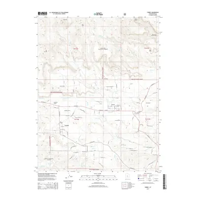
2014 Map of Torrey
USGS Topo · Published 2014About this map
Torrey and Teasdale serve as the primary nodes of settlement in this high-desert landscape, where the Fremont River and the hand-cut Torrey Canal provide essential water to the arid valley floor. The map illustrates a clear division between the irrigated agricultural plots around Poverty Flat and the surrounding high-elevation terrain. To the north, the topography rises toward Cooks Mesa and Hells Hole, while the southern reaches are dominated by the Dixie National Forest and features like Flatiron Lakes. Local history is anchored by the Torrey Cem and Teasdale Cem, which sit near the base of the Teasdale Bench. This 2014 survey documents the road network of the era, from the intersection of Highway 24 and Highway 12 to the local tracks of River Overlook Road.
Find a feature on this map
91 named features on this map. Tap any name to fly to it.
Don’t see what you’re looking for? This feature index may not catch every label — zoom into the map to look around manually.
Map Details
Editions of this 2014 Torrey Map
This is the sole edition of this map. No revisions or reprints were ever made.
Other maps of this area

1885 · Fish Lake
USGS Topo · 1:250,000

1896 · Fish Lake
USGS Topo · 1:250,000

1952 · Notom 2 NW
USGS Topo · 1:24,000

1952 · Loa 1 SE
USGS Topo · 1:24,000

1952 · Notom 3 NW
USGS Topo · 1:24,000

1952 · Notom 2 SE
USGS Topo · 1:24,000

1952 · Notom 2 SW
USGS Topo · 1:24,000

1952 · Notom 2 NE
USGS Topo · 1:24,000

1952 · Notom 3 NE
USGS Topo · 1:24,000

1952 · Grover
USGS Topo · 1:62,500