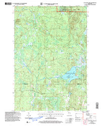
2005 Map of Totagatic Lake
USGS Topo · Published 2006About this map
Totagatic Lake and its surrounding wetlands form the center of this conservation-focused landscape on the border of Bayfield and Sawyer counties. The map details the Totagatic Lake State Wildlife Management Area, a region defined by its complex hydrologic network where the Ounce River and Totagatic River converge. High ground is marked by Smoky Hill, providing a contrast to the low-lying marshes near Tea Lake and Sabin Lake. Large portions of the terrain are managed as part of the Chequamegon Nicolet National Forest, specifically within the Drummond Washburn Ranger District. The absence of dense residential development is highlighted by the designation of the Big Brook Semi-Primitive Non-Motorized Area, emphasizing the era's commitment to preserving primitive forest character and protecting the headwaters of the West Fork Totagatic River.
Find a feature on this map
18 named features on this map. Tap any name to fly to it.
Don’t see what you’re looking for? This feature index may not catch every label — zoom into the map to look around manually.
Map Details
Editions of this 2005 Totagatic Lake Map
This is the sole edition of this map. No revisions or reprints were ever made.
Other maps of this area

1944 · Drummond
USGS Topo · 1:48,000

1944 · Hayward
USGS Topo · 1:48,000

1945 · Highland
USGS Topo · 1:48,000

1947 · Drummond
USGS Topo · 1:48,000

1947 · Chittamo
USGS Topo · 1:48,000

1949 · Chittamo
USGS Topo · 1:48,000

1949 · Highland
USGS Topo · 1:48,000

1953 · Ashland
USGS Topo · 1:250,000

1958 · Ashland
USGS Topo · 1:250,000
1961 · Ellison Lake
USGS Topo · 1:62,500