1991 Map of Tovar Mesa East
USGS Topo · Published 1991About this map
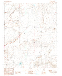
Tovar Mesa dominates this 1991 provisional survey, revealing a landscape defined by sharp escarpments and high desert plains in Navajo County. The settlement of Sa'lako and the locality of Tees Toh sit amidst a network of 4wd trails and unimproved roads, reflecting the enduring rural character of this portion of the Navajo Nation. These tracks connect remote landmarks such as several Water Tanks and a isolated Corral, which suggest the continued importance of livestock and water management in a region where surface water is scarce.
Find a feature on this map
12 named features on this map. Tap any name to fly to it.
Don’t see what you’re looking for? This feature index may not catch every label — zoom into the map to look around manually.
Map Details
Editions of this 1991 Tovar Mesa East Map
This is the sole edition of this map. No revisions or reprints were ever made.
Other maps of this area

1883 · Tusayan
USGS Topo · 1:250,000

1886 · Tusayan
USGS Topo · 1:250,000

1947 · Flagstaff
USGS Topo · 1:250,000

1954 · Flagstaff
USGS Topo · 1:250,000

1958 · Flagstaff
USGS Topo · 1:250,000

1960 · Flagstaff
USGS Topo · 1:250,000

1962 · Flagstaff
USGS Topo · 1:250,000
1966 · Egloffstein Butte
USGS Topo · 1:62,500
1966 · Tovar Mesa
USGS Topo · 1:62,500
1967 · Shonto Butte
USGS Topo · 1:24,000