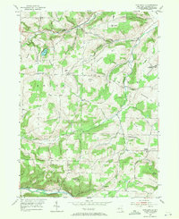
1953 Map of Towlesville
USGS Topo · Published 1971About this map
Towlesville sits at the heart of this rural landscape in Steuben County, where the hills of the southern tier are defined by family-named heights and scattered crossroads communities. The terrain is marked by prominent elevations like Bullard Hill and Hathaways Pinnacle, while drainage networks like Goff Creek and Campbell Creek carve through the upland plateaus. Local history is deeply etched into the land via numerous family and community burial grounds, including the Dublin Cem and White Cem, alongside small rural institutions such as the Oak Hill Ch and Sch No 3.
Find a feature on this map
46 named features on this map. Tap any name to fly to it.
Don’t see what you’re looking for? This feature index may not catch every label — zoom into the map to look around manually.
Map Details
Editions of this 1953 Towlesville Map
2 editions found
Other maps of this area

1910 · Bath
USGS Topo · 1:62,500

1915 · Hornell
USGS Topo · 1:62,500

1918 · Hornell
USGS Topo · 1:62,500

1924 · Woodhull
USGS Topo · 1:48,000

1926 · Woodhull
USGS Topo · 1:62,500

1926 · Greenwood
USGS Topo · 1:62,500

1944 · Woodhull
USGS Topo · 1:62,500

1950 · Elmira
USGS Topo · 1:250,000

1953 · Cameron
USGS Topo · 1:24,000
1953 · Bath
USGS Topo · 1:24,000