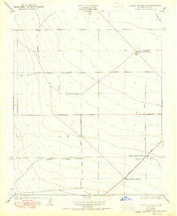
1950 Map of Towne Oil Station
USGS Topo · Published 1950About this map
Towne Oil Station sits at the heart of this Central Valley landscape, reflecting the agricultural and industrial character of Fresno County in the mid-20th century. The grid-like organization of the land is defined by prominent thoroughfares such as Elkhorn Avenue and Mt Whitney Ave, which facilitated the movement of goods and resources across the plains. This 1950 edition, based on earlier surveys by L.O. Newsome, captures the infrastructure of the local economy through features like the Crescent Ditch and the widespread irrigation networks essential for regional farming operations.
Find a feature on this map
15 named features on this map. Tap any name to fly to it.
Don’t see what you’re looking for? This feature index may not catch every label — zoom into the map to look around manually.
Map Details
Editions of this 1950 Towne Oil Station Map
This is the sole edition of this map. No revisions or reprints were ever made.
Other maps of this area

1912 · Coalinga
USGS Topo · 1:125,000

1923 · Englebrecht Ranch
USGS Topo · 1:31,680

1925 · Helm
USGS Topo · 1:31,680

1925 · San Joaquin
USGS Topo · 1:31,680

1928 · Delta Farms No 3
USGS Topo · 1:31,680

1931 · Wheatville
USGS Topo · 1:31,680

1931 · Towne Oil Station
USGS Topo · 1:31,680

1931 · Mouth of Cantua Creek
USGS Topo · 1:31,680

1932 · Delta Farms
USGS Topo · 1:31,680

1932 · West of Lethent
USGS Topo · 1:31,680