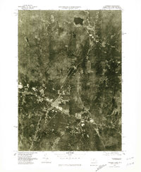
1975 Map of Townsend
USGS Topo · Published 1981About this map
Squannacook River and Nissitisset River define the wooded landscape of northern Middlesex County in this mid-1970s orthophotoquad. Unlike traditional topographic maps, this aerial perspective provides a literal view of land use patterns, showing the concentrated development at Townsend and West Townsend amidst dense forest cover. The photograph captures the village clusters of Townsend Harbor and the residential layout of South Row and Old City, revealing how these colonial-era settlements evolved within the narrow river valleys. In the north, the crossing into Brookline marks the transition toward the New Hampshire border. This visual record is particularly valuable for genealogists and local historians, as it depicts the exact footprint of properties and clearing limits before late-century suburban growth altered the rural character of the region.
Find a feature on this map
8 named features on this map. Tap any name to fly to it.
Don’t see what you’re looking for? This feature index may not catch every label — zoom into the map to look around manually.
Map Details
Editions of this 1975 Townsend Map
This is the sole edition of this map. No revisions or reprints were ever made.
Other maps of this area

1887 · Fitchburg
USGS Topo · 1:62,500

1889 · Fitchburg
USGS Topo · 1:62,500

1893 · Fitchburg
USGS Topo · 1:62,500

1893 · Groton
USGS Topo · 1:62,500

1900 · Peterboro
USGS Topo · 1:62,500

1906 · Milford
USGS Topo · 1:62,500

1931 · Groton
USGS Topo · 1:48,000

1931 · Fitchburg
USGS Topo · 1:48,000

1935 · Ayer
USGS Topo · 1:24,000

1935 · Groton
USGS Topo · 1:62,500