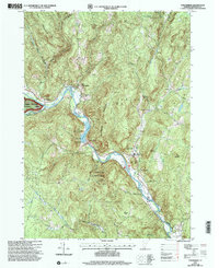
1997 Map of Townshend
USGS Topo · Published 2000About this map
The West River carves a winding path through the center of this Windham County landscape, anchoring a series of small riverside settlements including Townshend, West Townshend, Harmonyville, and Simpsonville. The 1990s terrain is dominated by the steep slopes of Rattlesnake Mountain and Bald Mountain, which overlook the engineering of the Townshend Dam and the sprawling Townshend Reservoir.
Find a feature on this map
38 named features on this map. Tap any name to fly to it.
Don’t see what you’re looking for? This feature index may not catch every label — zoom into the map to look around manually.
Map Details
Editions of this 1997 Townshend Map
This is the sole edition of this map. No revisions or reprints were ever made.
Other maps of this area

1889 · Wilmington
USGS Topo · 1:62,500

1891 · Wilmington
USGS Topo · 1:62,500

1891 · Brattleboro
USGS Topo · 1:62,500

1893 · Brattleboro
USGS Topo · 1:62,500

1894 · Londonderry
USGS Topo · 1:62,500

1899 · Londonderry
USGS Topo · 1:62,500

1899 · Wilmington
USGS Topo · 1:62,500

1930 · Saxtons River
USGS Topo · 1:48,000

1932 · Brattleboro
USGS Topo · 1:48,000

1933 · Saxtons River
USGS Topo · 1:62,500