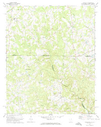
1971 Map of Tradesville
USGS Topo · Published 1973About this map
Lynches River carves through the center of this rural landscape, defining the topography of the Carolina borderlands in the early 1970s. The region is characterized by a dense network of small rural congregations and community hubs, including Tabernacle Ch, Rose Hill Ch, and Mt Zion Ch, which often served as the social anchor for surrounding farms. The settlement at Tradesville and the junction at Stewart Crossroads mark the primary points of habitation among the many creeks and branches. Notable water features like Buffalo Creek and Polecat Creek feed the larger river system, while the presence of Prospect Sch and numerous cemeteries suggests a long-established rural population. The map also delineates the state boundary line between North and South Carolina, crossing through the northern portion of the quadrangle.
Find a feature on this map
31 named features on this map. Tap any name to fly to it.
Don’t see what you’re looking for? This feature index may not catch every label — zoom into the map to look around manually.
Map Details
Editions of this 1971 Tradesville Map
This is the sole edition of this map. No revisions or reprints were ever made.
Other maps of this area

1941 · Spartanburg
USGS Topo · 1:250,000

1953 · Spartanburg
USGS Topo · 1:250,000

1960 · Spartanburg
USGS Topo · 1:250,000

1963 · Spartanburg
USGS Topo · 1:250,000

1964 · Spartanburg
USGS Topo · 1:250,000

1968 · Jefferson
USGS Topo · 1:24,000

1969 · Antioch
USGS Topo · 1:24,000
1969 · Taxahaw
USGS Topo · 1:24,000
1970 · Wingate
USGS Topo · 1:24,000
1970 · Waxhaw
USGS Topo · 1:24,000