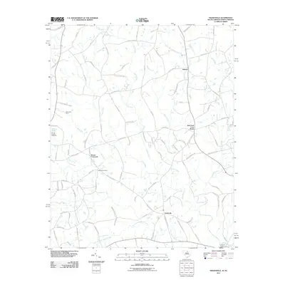
2011 Map of Tradesville
USGS Topo · Published 2011About this map
The Lynches River and its numerous tributaries, including Buffalo Creek and Polecat Creek, define the landscape of this rural Lancaster County borderland. Several small settlements anchor the crossroads of the region, including Tradesville, Stewart Crossroads, and Wolf Pond Cross Roads. For genealogists and local historians, the map identifies specific landmarks like Tabernacle Cemetery and the northern settlement of Trinity. The transport network is characterized by family-named routes such as Gulledge Parker Rd and Gus Eubanks Rd, suggesting a landscape deeply tied to multi-generational land ownership. Along the watercourses, engineering features like the Perry Lake Dam and Carnes Lake Dam indicate localized water management in a region defined by the drainage of Silver Run and the North Branch Wildcat Creek.
Find a feature on this map
91 named features on this map. Tap any name to fly to it.
Don’t see what you’re looking for? This feature index may not catch every label — zoom into the map to look around manually.
Map Details
Editions of this 2011 Tradesville Map
This is the sole edition of this map. No revisions or reprints were ever made.
Other maps of this area

1941 · Spartanburg
USGS Topo · 1:250,000

1953 · Spartanburg
USGS Topo · 1:250,000

1960 · Spartanburg
USGS Topo · 1:250,000

1963 · Spartanburg
USGS Topo · 1:250,000

1964 · Spartanburg
USGS Topo · 1:250,000

1968 · Jefferson
USGS Topo · 1:24,000

1969 · Antioch
USGS Topo · 1:24,000
1969 · Taxahaw
USGS Topo · 1:24,000
1970 · Wingate
USGS Topo · 1:24,000
1970 · Waxhaw
USGS Topo · 1:24,000