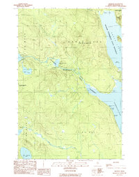
1989 Map of Tramway
USGS Topo · Published 1989About this map
The Allagash Wilderness State Waterway serves as the focal point for this survey of the North Maine Woods, capturing a landscape defined by timber history and recreational transit. The eponymous settlement of Tramway stands on the narrow neck of land between Eagle Lake and Chamberlain Lake, marking the historic portage point where industrial infrastructure once moved logs between watersheds. An Old Railroad Grade traces the eastern shore of Chamberlain Lake, providing a physical record of the rail-and-water logistics that dominated this region's early economy.
Find a feature on this map
26 named features on this map. Tap any name to fly to it.
Don’t see what you’re looking for? This feature index may not catch every label — zoom into the map to look around manually.
Map Details
Editions of this 1989 Tramway Map
This is the sole edition of this map. No revisions or reprints were ever made.
Other maps of this area

1954 · Chesuncook
USGS Topo · 1:62,500

1954 · Caucomgomoc Lake
USGS Topo · 1:62,500

1954 · Churchill Lake
USGS Topo · 1:62,500

1954 · Allagash Lake
USGS Topo · 1:62,500

1954 · Presque Isle
USGS Topo · 1:250,000

1958 · Presque Isle
USGS Topo · 1:250,000

1958 · Chesuncook
USGS Topo · 1:62,500

1958 · Caucomgomoc Lake
USGS Topo · 1:62,500

1960 · Presque Isle
USGS Topo · 1:250,000

1961 · Allagash Lake
USGS Topo · 1:62,500